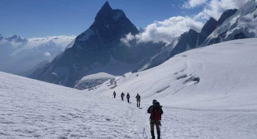
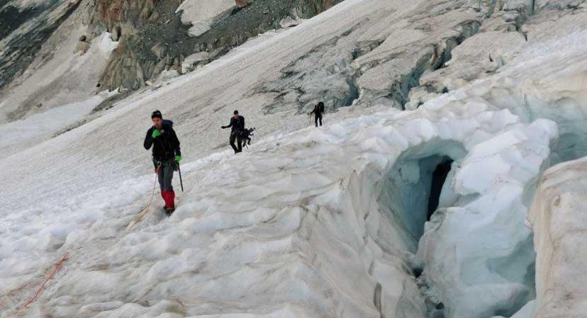
The classic trek from the Mont Blanc Massif follows the Haute Route to Zermatt. The route crosses many glaciers, with views of most of the 4000-meter peaks of the Alps. Along the way, several summits will be climbed.
The Haute Route is essentially a classic, strenuous ski touring route. It leads from France, from the foot of Mont Blanc past the Grand Combin and the Matterhorn to the Swiss Zermatt.
The route dates from the late 19th century, a time when mountaineering was still emerging and mainly practiced from the mountain villages of Chamonix and Zermatt. The ‘Haute Route’ connected these climbing centers via a series of famous mountain passes.
Note: This route has been promoted in the past by the NKBV. Due to possible changing conditions, you are always responsible for checking the current route conditions yourself. Get informed by the local tourist office or experts in the respective region to travel safely and well-prepared.
Itinerary
Best period to go there
Prestations
Author\s note
For information about accommodation in Chamonix, you can visit: www.chamonix.com. Here you can also find options for acclimatization walks, which are absolutely necessary.
On www.zermatt.ch you can find information about overnight accommodations in Zermatt.
Directions
Day 1
Le Tour/Chamonix (1453 m) – Refuge d’Albert Ier (2702 m)
Hiking time: 3 hours
Altitude difference: +600m
Start with the lift to Charamillion.
Day 2
Refuge d’Albert Ier – Col supérieur du Tour (3289 m) – Refuge du Trient (3170 m)
Hiking time: 5 hours (+ extra for exercises)
Altitude difference: +500m, -200m
Day 3
Cabane du Trient – Grands Plans (2188 m) – Champex (1498 m) – Bourg-Saint-Pierre (1632 m)
Hiking time: 5 hours
Altitude difference: +100m, -1100m
Cable car from Grands Plans to Champex-Lac. Then bus to Bourg St. Pierre.
Day 4
Bourg-Saint-Pierre – Cabane du Valsorey (3030 m)
Hiking time: 5 hours
Altitude difference: +1400m
Day 5
Cabane du Valsorey – Col de Méitin (3611 m) – Glacier de Corbassière – Cabane François-Xavier Bagnoud à Panossière (2669 m)
Hiking time: 6 hours
Altitude difference: +600m, -1000m
Day 6
Cabane François-Xavier Bagnoud à Panossière – Col des Otanes (2873 m) – La Tseumette (2297 m) – Lac de Mauvoisin (1970 m) – Cabane de Chanrion (2462 m)
Hiking time: 8 hours
Altitude difference: +1250m, -1450m
Day 7
Cabane de Chanrion – Glacier de la Serpentine – Pigne d’Arolla (3796 m) – Cabane des Vignettes (3160 m)
Hiking time: 7 hours
Altitude difference: +1300m, -600m
Alternative in worse weather:
Cabane de Chanrion (2462 m) – Col de Chermotane (3053 m) – Col des Vignettes – Cabane des Vignettes (3160 m)
Hiking time: 6 hours
Altitude difference: +820m, -150m
Day 8
Cabane des Vignettes – Col de Chermotane (3053 m) – Col de l’Evêque (3392 m) – Col Collon (3087 m) – Cabane de Bertol (3311 m)
Hiking time: 8 hours
Altitude difference: +1240m, -1060m
If no Pigne d’Arolla yesterday then today:
Altitude difference: ascent and descent 640 m.
Day 9
Cabane de Bertol – Glacier du Mont Mine – Tête Blanche (3710 m) – Stöckji – Schönbielhütte (2694 m)
Hiking time: 8 – 10 hours
Altitude difference: +500m, -1100m
Day 10
Schönbielhütte – Zermatt (1616 m)
Hiking time: 4 hours
Altitude difference: -1100m
Getting there
By car:
If traveling by car, it is more convenient to park the car in Brig or near Täsch and use public transport to go to Chamonix.
Parking space available at stations in Brig and near Täsch
Day and night train: Amsterdam-Montroc le Planet
Return: Zermatt-Amsterdam.
By train to Martigny and from there by train to Chamonix. Get off in Montroc. Then approximately a 20-minute walk to the CAF Chalet.
In Zermatt, train to Visp – Brig and from there Basel / Amsterdam